Tag Archives | Bald Eagles

Dye Creek Preserve Outing

Located in the foothills below Mount Lassen, the 37,540-acre Gray Davis Dye Creek Preserve is an expansive landscape of blue oak woodlands, volcanic buttes, and rolling wildflower fields. The landscape is dissected dramatically by Dye Creek Canyon with its vertical cliffs, clear-water creek, and diverse riparian forests. The forest widens as it leaves the canyon mouth and flows westward, through wetlands, to its confluence with the Sacramento River. Join Larry Jordan, trip leader, for a hike up Dye Creek Canyon. Golden Eagles, Peregrine Falcons and Canyon Wrens are a possibility. Wild flowers should be abundant. The three mile trail is rough so be prepared. Bring water, a lunch, and sturdy shoes for this all day outing. Meet at 7:30 sharp at the Kutras Park on Park Marina Drive to caravan and bring a lunch for this full-day trip. We will bird along Foothill Road on the way with each vehicle having a walkie-talkie to communicate birds seen.

*Participants are required to have proof of full COVID-19 vaccination and sign a Wintu Audubon waiver as well as the Nature Conservancy waiver.

0

Sacramento National Wildlife Refuge Outing

The Sacramento National Wildlife Refuge is a national gem, well worth the short, 90 mile drive to Willows. Enormous numbers of waterfowl fill the sky and the impoundments in fall and winter. Snow, Ross’s and Greater White-fronted Geese, Northern Pintails, Northern Shovelers and Gadwalls are assured. Possibilities are White-faced Ibis, Green-winged and Cinnamon Teal, Black-necked Stilts and various raptors, including Bald Eagle and Peregrine Falcon. Most of the birding is done from cars. We will provide 2-way radios to report sightings and alert people in other cars to look for them. Meet your leader at 7:30 am sharp at Kutras Park on Park Marina Drive to carpool or at the visitor center at 9:00am, and bring a lunch for this full-day trip. Fees to enter the refuge are $6 per car for the day. Most carpool drivers have senior lifetime passes and can enter for no additional fee. For more information call Larry Jordan @ 949-5266

*All participants, ages 5 and older, must provide proof that they are fully vaccinated against COVID-19 or provide evidence of a negative COVID-19 test within 72 hours prior to the field trip. Participants must practice social distancing when outdoors on field trips and must wear masks and practice social distancing while indoors. Participation is not currently allowed for persons under the age of 5.

0

Turtle Bay Provides Natural Wealth

It is the Thanksgiving season, and Redding has a special treat to appreciate. We have naturally what many cities spend a lot of money striving for: a place like Turtle Bay.
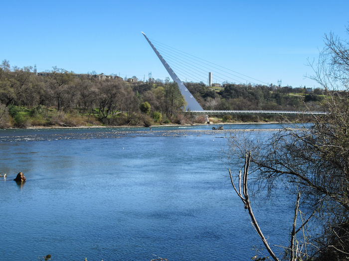
Sundial Bridge

On any temperate morning, and many others too, the Bird Sanctuary Loop is the hub for a stream of cyclists, dog-walkers, joggers, retired couples, friends, young families, and bird-watchers. Children gaze at green-headed mallards and study the giant webs of garden spiders.  Parents guide their children to the trailside as bell-ringing cyclists approach. Walkers watch jacketed fishermen float below them, their boats drifting, their lines in the water. In fall, when the weather is right, the trails and visitors can be showered with golden leaves.
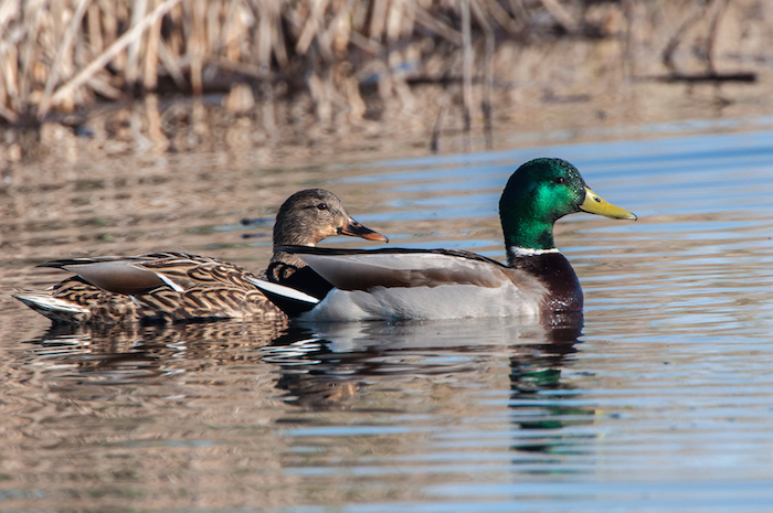
Mallard Pair

Mallard Pair

This welcoming and well-traveled route lies in the heart of Redding, nestled inside a bend in the river that creates the maze of bywaters and peninsulas that, together with the main river channel, comprise Turtle Bay. The green and brindled landscape nurtures a complex of aquatic insects and snails, and the fish, river otters, birds, and fisherfolk they support. The riparian woods house red-shouldered hawks, woodpeckers, and the numerous birds that nest in the cavities they excavate.  Quiet inlets make restful wintering grounds for geese and hundreds of ducks including mallards, ring-necks, shovelers, and teal. Herons and egrets stalk the shallows, and kingfishers plunge into clear pools. Out in the river’s main current golden-eyes dive for bugs while grebes and red-coiffed mergansers chase fish. At Turtle Bay nature quietly offers a fundamental experience of life–its giving and its taking back, its patterning and variety, its beauty.

Barrow's Goldeneye Pair

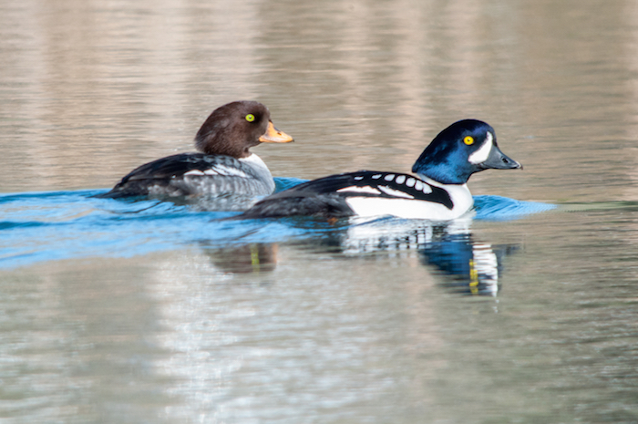
Barrow’s Goldeneye Pair

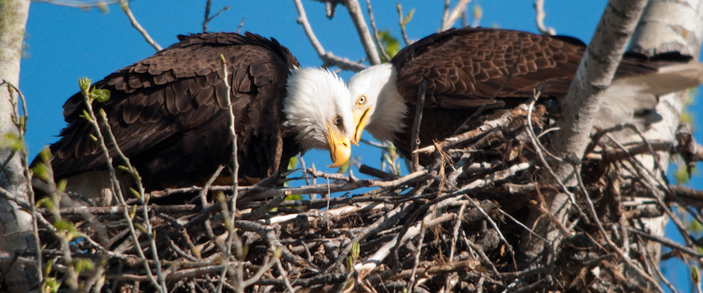
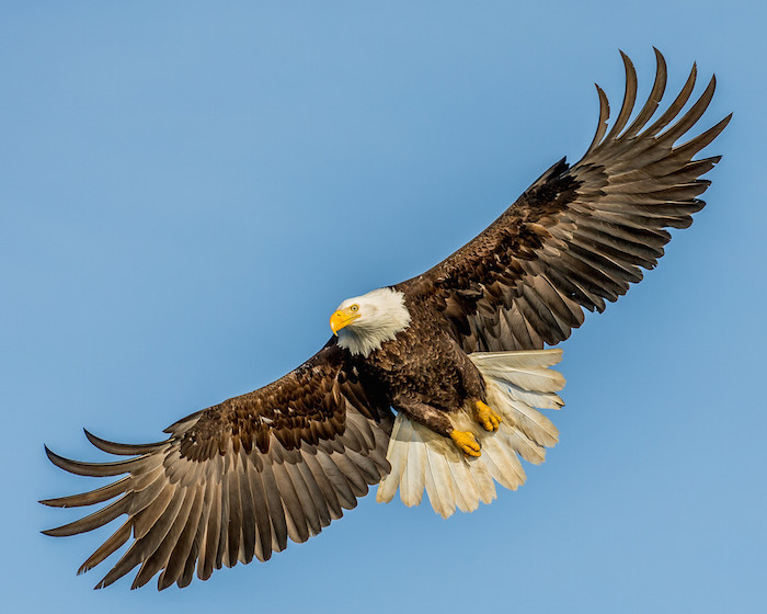
But the wealth of Turtle Bay is not just the bend in the river. The bay is part of a corridor. Just as the Bird Sanctuary Loop is part of the larger River Trail, the Bay and its wildlife are part of the flowing water and the riparian woods, upriver and down. Each fall thousands of yellow warblers follow the river, scouring the riverside trees for insects to fuel their long flights to wintering grounds in Central America. Tanagers flock through, the males’ flame-red heads eclipsing into their yellow-greens of winter, as they gorge on the ripened grapes espaliered on towering cottonwood trees–again, fueling long flights south. Swallows–the orange-rumped cliff swallows that build homes under the Sundial Bridge, the shining blue tree swallows and violet-greens that nest in old woodpecker holes, and the rough-winged swallows that make homes in weep-holes at the Bella Vista water intake, all capture insects on the wing, skimming the river surface or circling high in the sky, first here where they hatch and then all along the river as they migrate. Redding’s famous eagles have fledged twenty eaglets at Turtle Bay; they, too, travel the corridor, both seasonally and a few years ago to try nesting downstream at Riverview Golf Course, where they fledged young but lost three nests before returning to their more reliable home at the Bay.
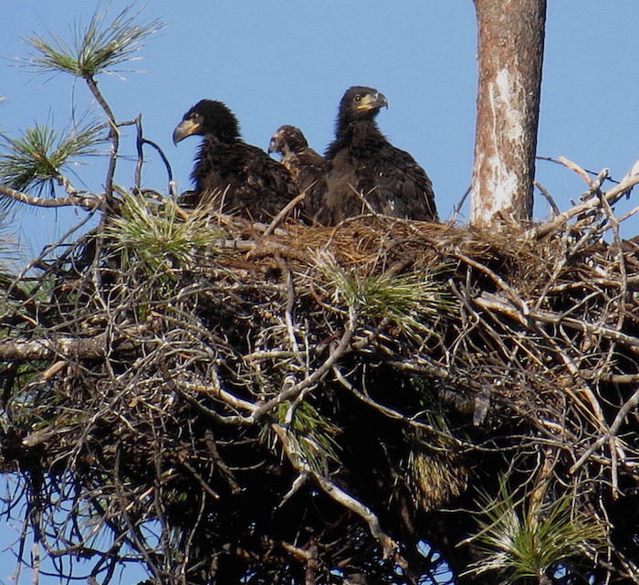
Redding Eagles

So far the Sacramento River corridor remains largely free of commercial development, allowing clean bywaters and riverine woods to grow the bugs that feed the fish and birds and other riparian life. Upriver from Turtle Bay the woods still flourish up to the dams, perhaps most broken at Redding’s Rodeo grounds, where the thin riverside forest has received a strip of welcome
replanting. Downstream, aside from the development along Park Marina Blvd, the riverbanks are substantially verdant.

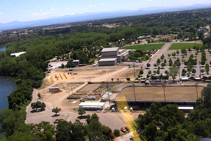
Redding Rodeo Grounds

Now the city is considering selling land at Turtle Bay for commercial development. As this is written, the City Council is pursuing the land sale, while unofficially assuring that the Bird Sanctuary itself will be retained and spared the pavement, at least for now. Unfortunately, the biology of the Bay stands to lose regardless, because its life runs up and down the river.

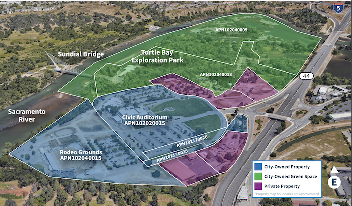
City Council has seemed genuinely interested in getting public input: should the sights and sounds of riverside plants and wildlife be retained with permanent, broad setbacks for riparian woodlands?  Should development be kept to areas that are already paved, perhaps diverted to Park Marina? Will a dressed-up Convention Center and more restaurants draw the revenue of visitors from the Bay Area and farther off? Ultimately, will selling riverine public lands for development improve the quality of life for citizens now and in the future?  Your City Council wants to know what you value. You can reach them through cityofredding.org .

0

As The Nest Turns: The Continuing Saga of the Redding Eagles

Bald Eagles Patriot & Liberty

Terri Lhuillier will share the continuing saga of our famous Redding Eagles as she begins her 17th Nesting Season closely monitoring the local bald eagle pair. Terri has been following “Liberty” for 17 years since the bald eagle pair first arrived & built a nest at Turtle Bay in Redding back in 2004. She has spent numerous hours observing, documenting & photographing Liberty with her 3 mates as they successfully raised 22 eaglets from egg to fledgling!

Terri will discuss how her passion for eagles has grown over the years and how now, she and her husband Dave, monitor seventeen bald eagle nests in Redding, Anderson, Palo Cedro, Red Bluff and Corning. Terri and Dave document annual nesting data for the nests which they share with several Fish and Wildlife and Whiskeytown biologists to help them monitor the local bald Eagle population.

Wintu Audubon Society is inviting you to a scheduled Zoom meeting.

Topic: As The Nest Turns: The Continuing Saga of the Redding Eagles
Time: Jan 13, 2021 07:00 PM Pacific Time (US and Canada)

Join Zoom Meeting
https://zoom.us/j/91500644744

Meeting ID: 915 0064 4744
One tap mobile
+16699006833,,91500644744# US (San Jose)
+12532158782,,91500644744# US (Tacoma)

Dial by your location
+1 669 900 6833 US (San Jose)
+1 253 215 8782 US (Tacoma)
+1 346 248 7799 US (Houston)
+1 312 626 6799 US (Chicago)
+1 929 205 6099 US (New York)
+1 301 715 8592 US (Washington D.C)
Meeting ID: 915 0064 4744
Find your local number: https://zoom.us/u/acIVevKNJH


0

The Redding Christmas Bird Count: a History

Great-tailed Grackle Male

Great-tailed Grackle

Up through the 19th century many folks in this country celebrated the Christmas season in “side hunts” in which they competed at how many birds they could kill, regardless of whether they had any use for the carcasses and of whether the birds were beneficial, beautiful, or rare. Ornithologists and bird watchers were appalled at the slaughter. In December 1900, Frank Chapman an early officer in the nascent Audubon Society proposed a new holiday tradition—a “Christmas Bird Census” that would count birds during the holidays rather than hunt them. On Christmas Day of that year 27 birders took part in 25 places in the United States and Canada. Since then participation has grown every year, now exceeding 80,000 people in 2,400 locations in 17 countries.

Bird Hunting

Shasta County participation, conducted by the Lassen Bird Club, began briefly in the late 1950’s but ended when the club folded in 1967. The first project of the newly formed Wintu Chapter of the National Audubon Society was the Christmas Bird Count in 1975. It was soon followed by a Count in Fall River Valley, Red Bluff and more recently Anderson. All Counts follow a standard protocol. The count is performed any day from December 14 to January 5 within “a count circle” with a diameter of 15 miles. The Redding Count is centered just north of Keswick Dam and extends north to Shasta Dam, south to Clear Creek, west to Oak Bottom Marina on Whiskeytown Lake, and east to Shasta College. It is designed to include a variety of habitats, open water, valley grasslands, oak woodlands, brush lands and conifer forest–and, of course, an increasing portion of urban and suburban habitat. The circle is divided into 10 sectors with a team leader assigned to each sector. Teams count from dawn to dusk rain or shine every bird they see by species. Participation is open to all and is free of charge. At the end of the day participants gather at a local restaurant for a no-host dinner and a compilation of the results. Learning the surprise findings of other teams is fun and emphasizes the old adage that “birds are where you find them” not always where you expect them.

The results are by no means as accurate as a human census. The experience of the birders, the weather, and the changing quality of locations examined, all influence both species identification and number of individuals. Not all of the area in the count circle is covered, and not every bird along the route is seen or identified. Big flocks can’t be counted precisely. Also, telling whether a bird has been counted twice can be difficult. A Bald Eagle in flight over the count circle may be counted by several teams, whereas only a fraction of the White-crowned Sparrows in the roadside bushes might be counted. The strength of the results lies in the long-term trends in species numbers, recognizing that the habits of birds and people remain the only constant.

Bald Eagle in flight photo courtesy Andy Morffew

Our results are sent to the National Audubon Society that along with other organizations uses data collected in this long-running wildlife census to assess the health of bird populations, and to help guide conservation action. For example, the Environmental Protection Agency (EPA) has included Audubon’s climate change work from CBC data as one of 26 indicators of climate change in their 2012 report.

Western Meadowlark

Western Meadowlark

Now with 45 years of Christmas Bird Counts here in central Shasta County several clear trends are apparent. As expected, urban development within the count circle has reduced the habitat available for Western Meadowlarks and California Thrashers. The range expansion of Great-tailed Grackles, originating from the southeastern U.S., reached the Redding Area in 2010 and now has several established sites at Lema Ranch and the Clover Creek Preserve. The Common Raven has made a strong move into the valley and downtown Redding beginning in 2007. You can now see them on light poles along busy streets. The Red-shouldered Hawk habitat in central Shasta County historically was confined to riparian vegetation along the Sacramento River. Since 1997 it has expanded its range and can be found on farms and rural subdivisions throughout the valley. Perhaps most spectacularly, the Eurasian Collared-dove arrived in the Redding area in 2008 and is now well-established at about 60 individuals throughout Redding neighborhoods. You are probably aware of its tiresome hooting, a pushier sound than the coo of our native Mourning Doves.

Mourning Dove

Mourning Dove

These are just some of the trends the Redding Christmas Bird Count has documented.

0